Wait. If that’s a real thing and not fake news — the government taking action to flood thousands of homes in a weather emergency — why is some dude at the weekly paper the one trying to get ahead of it? The federal government flooding people?
If it's real, why is it not front and center for the local mayor and the city council and the legislators and the members of Congress? Yeah. You tell me. It’s not. Radio silence. So I’m what you got.
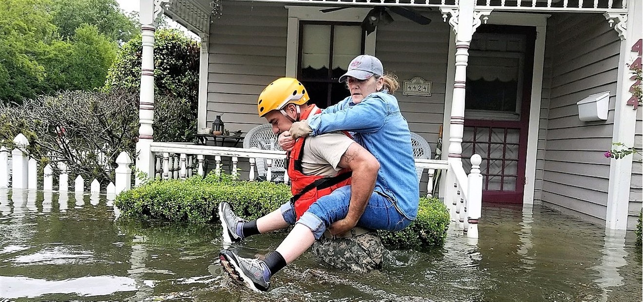
It’s a real thing in Houston. After Harvey, all of the public officials from Houston City Hall to the United States Army Corps of Engineers conceded that entire subdivisions in Houston were inside two normally dry reservoirs built 70 years ago. When Harvey’s 50-inch rainfall filled the Addicks and Barker reservoirs, thousands of homes were flooded inside and upstream of the reservoirs. Then when USACE let water out of the reservoirs to ease pressure on the dams, thousands more were flooded downstream.“For the U.S. Army Corps of Engineers (USACE) owned and operated lakes in Texas, we do not post inundation maps for public use.”– Clayton A. Church
tweet this
But it’s a real thing here, too. Dallas has an array of flood-safety reservoirs, poised like swords of Damocles over downtown and much of the city’s urban core. We get extreme weather here, too. We just finished the city’s wettest winter on record. And it’s important to remember that our reservoirs began the winter almost at capacity and have nudged up over capacity, as they are now, twice since then.
Yes, Harvey’s 50 inches of rain from one storm was wildly more severe than our 16 inches total over the winter. But Addicks and Barker were dry when Harvey hit. Here, it takes a lot less rainfall to push reservoirs that are already almost at capacity into the kind of emergency condition in which the Corps must begin releasing enough water to flood people downstream.
On the one hand, no worries: USACE has precise maps showing who will get flooded upstream and downstream in the event of an inundation. On the other hand, worries: USACE won’t show the maps to you.
I asked the Fort Worth regional headquarters of USACE to give me the inundation maps for all of the nine Dallas-area federally owned reservoirs. Clayton A. Church, a spokesman for the USACE Fort Worth District, told me, “For the U.S. Army Corps of Engineers (USACE) owned and operated lakes in Texas, we do not post inundation maps for public use.”
Church sent me a USACE circular called Flood Inundation Mapping and said, “Please read carefully paragraph seven.” I read it as carefully as I could. It says, “FIM (flood inundation maps) developed to support EAPs (emergency action plans) around systems where USACE operates flood risk management infrastructure (i.e. levees and dams) are not releasable to the public, but are shared with federal agencies and state and local governmental organizations.”
That seemed clear, sort of, maybe not entirely, possibly not at all. I was sort of stumbling on the difference between “the public” and “state and local governmental organizations.” My understanding is that most of the time the term public means everybody, whether they work for a local governmental organization or, you know, for a skate park, and once the government releases something, it’s public. Anybody has a right to it.
Of course, distinctions can be made between entities in law enforcement or emergency response and entities or people outside those realms. The FBI can share information with a local sheriff, and that doesn’t make the information public. But I didn’t see any limiting language in the circular restricting the release of the inundation maps only to certain agencies with a public safety mandate.
In fact, the circular goes on to say that local governments can release the mapping to property owners if they request it. So at that point, the maps become public. But if they can become public after they leave the hands of USACE, why aren’t they already public when they are still in USACE’s hands?
I ran some of this by Bryant S. Banes, the attorney representing flooded homeowners in Houston in one of two Harvey-related lawsuits against USACE. Banes told me that Church of the USACE Fort Worth Division had sent me the right circular on USACE inundation maps but had directed me to the wrong paragraph. Banes told me to carefully read paragraph 11.
Oh, my. Paragraph 11 says the information that USACE possesses on who is going to get flooded out — even when the information is still only preliminary — is so important that it should be shared with the public:
“Depending on the quality and accuracy of the source data,” paragraph 11 of the USACE circular states, “inundation model results vary greatly in quality and accuracy. Sharing those results with the state and local emergency response authorities, community and public, even when preliminary, promotes preparedness, emergency response, and recovery efforts.”
Well, wait a minute. One paragraph says the maps or models are not “releasable to the public.” But a few paragraphs later, the circular says the “community and public” should be given the information even when it’s still in preliminary form, with appropriate disclaimers. So which is it?
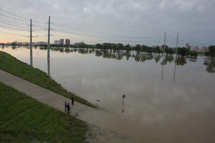
In 2015, the Trinity River through downtown rose to high levels as federal reservoirs upstream exceeded their limits.
Nicholas Henderson
In reporting by the Houston Chronicle, Pro Publica and The New York Times, a distinct theme emerges in the backstory of Harvey, the prequel. Knowledge of the inundation zones or easements has always been explosively political and controversial when the Corps does not own the land in the easement.
Decades ago when Addicks and Barker were new, some public officials in Houston argued that anyone developing and selling land within the inundation easements should be required to inform every potential buyer that the land would be flooded in certain extreme weather events. But there was huge pushback from the real estate interests.
Those of us who were around during the boom years remember that raw-land residential development in Houston raged across the rice fields like a brush fire, driven this way and that by the merest vagaries of chance and advantage. The same thing was going on here, as one little dried-out cotton town exploded into subdivisions and shopping centers while the one just down the road languished.
If you owned land out there that lay within an inundation easement and had to tell every buyer about it, you might as well have folded up shop and gone into the ministry. You sure weren’t going to do any good in the real estate business."Sharing those results with the state and local emergency response authorities, community and public, even when preliminary, promotes preparedness, emergency response, and recovery efforts.” – USACE
tweet this
The raw-land development interests held great sway over local public policy in the major growth cities in Texas then, and nowhere was that more true than here. During most of the 1980s, the mayors of Dallas were also the biggest residential real estate developers outside of Dallas in the new raw-land universe. From transportation to flood control, all local public policy was bent steeply toward the facilitation of sprawl.
This puzzle has another important piece. Of all the parts of the federal government, none is more dependent on local politics than USACE. USACE is basically a government-owned public works construction company. Its only budget is money the Congress grants it for local projects. By law, those projects must be joint ventures with local government partners. No more local government partners, no more USACE, so USACE has an existential incentive to keep the local boys grinning.
Houston has now devolved into an almost farcical round of finger-pointing, with officials at City Hall pointing fingers at Harris County and the county pointing back at the city and all of them pointing at the public, everybody but the public saying that everybody else always knew where the flooding would occur and somebody else should have told somebody. Or done something. Or something.
That’s exactly what will happen here. As the lawyers in the two Houston lawsuits have established, the information was always supposed to be public. Everyone here should know exactly where the flooding will occur if area reservoirs get backed up upstream or if emergency releases are made downstream.
The maps should be online. There is no legal reason for them not to be. There are powerful public safety reasons why they should be. The maps are not online because of resistance from the real estate development industry, abetted by local officials and USACE, in direct violation of the public interest and public safety.
In my last communication with USACE Fort Worth, I made a formal request for the maps under the federal Freedom of Information Act. That was March 22. I have heard back not one peep as yet. Depending on how you count the days, USACE has until approximately Wednesday, April 11, to acknowledge receipt of my request. I will keep you posted.
In the meantime, there’s a lot of story in the fact that the maps have not always been public and that I have to be the guy making a legal request to get them. It simply should not be that way.