
Eric Vryn/Getty Images

Audio By Carbonatix
Editor’s Note: For this story, Isaac Mayer and Sandra Kazansky are pseudonyms we have given to two sources who requested anonymity due to concerns over possible retaliation.
If it weren’t so upsetting, Isaac Mayer would laugh about how little Texas’ regulatory agencies seem to care about what he believes to be a significant flood risk near Mineola.
A few months ago, Mayer was in the “right place at the right time” when he overheard a conversation about dredging that took place in 2020 at Rock Falls Lake in Wood County, about two hours east of Dallas. The dredging, he discovered, was substantial, and he worries the millions of gallons of water added to the lake could be dangerous because the lake sits within a FEMA Flood Zone A, one of the highest-risk designations.
An investigator would be needed to tell how dangerous the added water and the pressure its weight adds to the dam might be. The hard part is finding one willing to take a solid stance on the issue.
A dredge report indicates that 3.3 million gallons of water were added to the lake, which is around 52 acres and a privately owned recreational fishing spot. The dredging was commissioned by the local fishing club and took place over three dates in October and November 2020, invoices show. The total cost for the work was $114,999.
Freedom of Information Act requests, database searches and statements from several regulatory agencies suggest the fishing club did not obtain significant permits before working in a flood zone. Dredging is the process of removing sediment and mud from the bottom of a body of water, often to maintain a waterway. In a recreational lake, dredging can benefit fishing conditions by increasing water depth and improving the aquatic ecosystem.
The Army Corps of Engineers has no record of any permit related to dredging at Rock Falls Lake being filed in the last 125 years, a response to a records request stated. The Texas Commission on Environmental Quality, which regulates private and public dams across the state, also does not have a record of any permits related to dredging being filed in the area. (The dam on the eastern side of Rock Falls Lake is around 120 years old and, according to a letter from the TCEQ, exempt from inspection.)
Local officials could not confirm whether their offices ever received associated permit applications. In a statement to the Observer, FEMA said there have been no changes to the region’s Flood Insurance Rate Map – the document that identifies flood hazard risks within an area and should be updated to include significant new developments – since 2010.
Mayer says state agencies have failed to act urgently despite his efforts to raise awareness. Private residences sit around the lake’s edge, and satellite images show buildings within the floodplain directly downstream of the dam.
“If that dam breaches, it’s going to kill a lot of people and destroy a lot of property,” Mayer told the Observer. “That’s why I’m trying to get people to pay attention.”

The Rock Falls dam is on the eastern side of the lake. While the floodplain around the immediate body of water is narrow, it balloons outward downstream.
FEMA
The Observer could not find a social media profile or website for the Rock Falls Fishing Club, and phone calls to several numbers reportedly associated with the club went unanswered. The private company listed on the dredge report, American Sport Fish Hatchery, did not respond to multiple requests for comment, although its website suggests it does provide dredging services.
Preventing Flooding Tragedies in Texas
Mayer first learned about the dredging at Rock Falls Lake in March. At that point, he and a group of residents began filing records requests to learn about the extent of the work. They also began reaching out to state agencies in hope that someone would open an investigation into the dredging’s impact on the flood zone and dam.
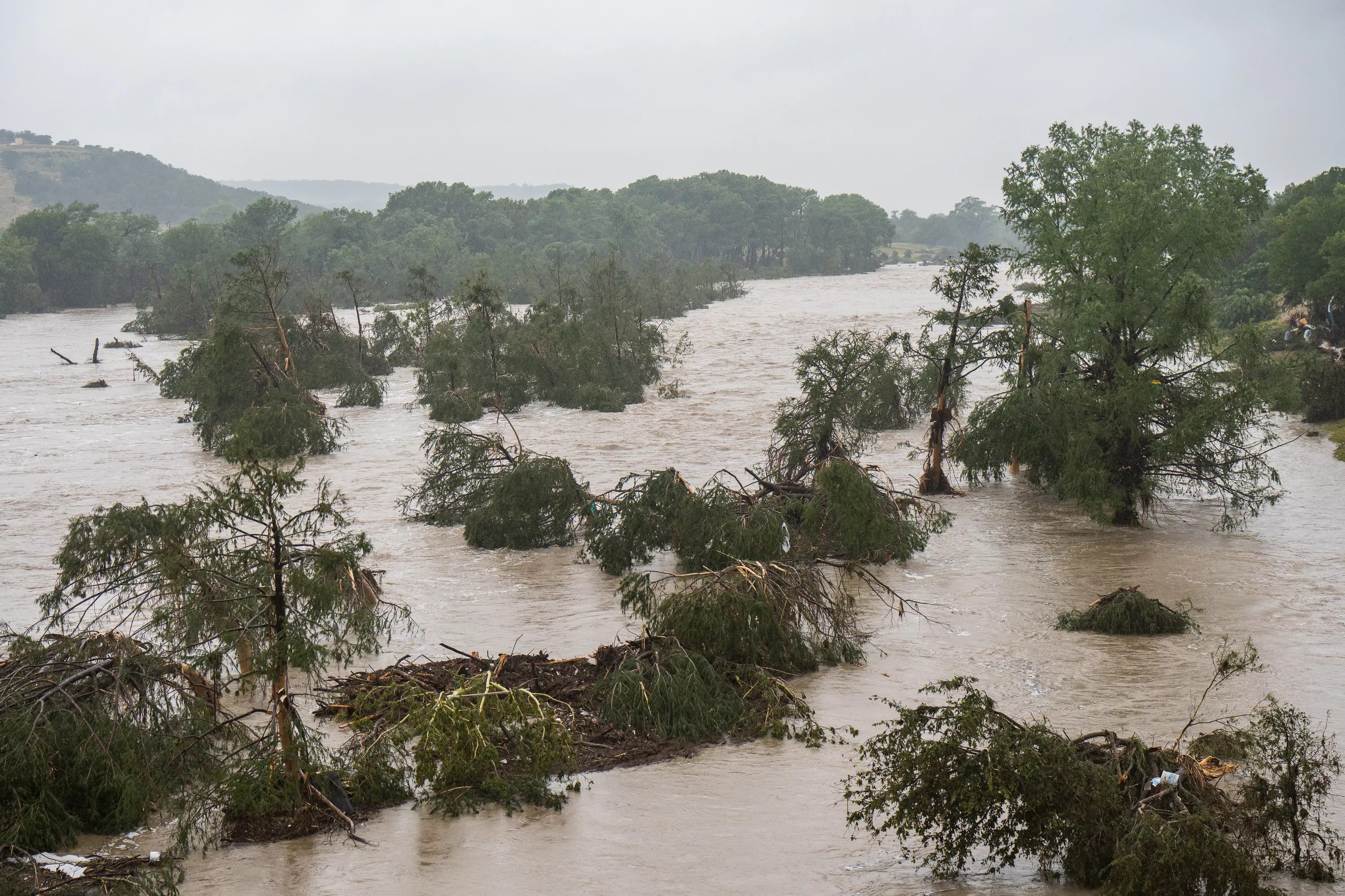
Then, in July, flooding in Texas’ Hill Country killed at least 135 people, including 27 campers and counselors at the overnight camp Camp Mystic. The deaths spurred a wave of scrutiny over Texas’ flood procedures and inspired legislation during the second special session in August.
“We can do better,” said state Rep. Ken King, a Republican from the Panhandle, after chairing the House Committee on Disaster Preparedness & Flooding. “Being prepared and being ready to respond to a disaster is what we owe the citizens of Texas.”
Even after the July 4 flood, Mayer and his colleague, Sandra Kazansky, who has made a career of investigating environmental issues, say they have yet to see the changes promised by lawmakers in Austin.
“It’s so obvious to me how Kerr County happened,” Kazansky says. “Everybody passes the buck to somebody else, and there’s no accountability when people’s lives are at risk.”
Rock Falls Lake is in a FEMA Flood Zone A, the same designation as some of the cabins at Camp Mystic. Zone A areas have a 1% annual chance of flooding, and building (or dredging) within a Zone A floodplain requires a special set of permits because of the risks it could pose.
“This has exposed a sad part of our state government. This isn’t a Mineola issue. This is an issue across Texas.” – Isaac Mayer, whistleblower
Determining what can be built or what work can be done within a flood zone is typically left to local floodplain administrators, although permits from larger agencies, such as the U.S. Army Corps of Engineers, are also required. According to FEMA, local floodplain administrators are responsible for issuing permits for developments within flood-prone areas, ensuring that developments meet minimum federal standards and assessing any downstream risks a particular project may pose.
The floodplain administrator for Wood County, where Rock Falls Lake is located, declined to tell the Observer whether any permits were ever filed with his office for the lake’s dredging.
“I don’t know how to answer that question,” the administrator, Tully Davidson, said when asked whether his office handles permitting at all.
Davidson added that he is unsure if regulating dredging is within his office’s purview. A Wood County floodplain development permit application found online suggests that “Alteration of a Natural Waterway” is one of seven types of proposed developments for which the office accepts permit applications.
The U.S. Army Corps of Engineers also requires permits for “excavation, dredging, filling and depositing dredged materials.” An official with the Southwestern Division’s regulatory office confirmed to the Observer that no permits for the dredging were filed with the Corps before the work was done, and that an investigation into the dredging has been opened. However, whether the issue will ultimately fall under the Corps’ jurisdiction remains to be determined, as the agency only regulates “some types” of dredging.
The Texas Water Development Board, an agency that helps coordinate Texas’ flood planning efforts and local flood plain administrators, did not respond to multiple requests for comment. The Texas Division of Emergency Management, which helps “implement plans and programs to help prevent or lessen the impact of emergencies,” also did not respond to a request for comment. However, one official with the Region 3 office (which includes Wood County) said that, having started in the role two years ago, he wouldn’t know about any dredging that took place in 2020.
“The more you dig, the less you find good answers that feel comfortable to you,” Kazansky said. “My drive here is for the welfare of the people in the community. The more that I learned about this situation, the more appalled I was and the more I dug in to find out how this happened. … I can’t sleep at night knowing I had information and nothing was done.”
A System Under Stress
Mayer and Kazansky believed they’d finally found an agency to take their worries seriously last month, when an engineer with the Texas Commission on Environmental Quality expressed dismay when shown the Rock Falls Lake dredge report.
“His actual words were ‘This is despicable. How could they add all of those millions of gallons of water to that lake and do that dredging without a permit? Without talking to us?’ And I said, ‘That’s why I’m calling you,'” Kazansky said.
Just a few weeks after that call, though, Mayer received a letter from the TCEQ’s dam safety program informing him that the agency isn’t responsible for investigating the Rock Falls Lake dam after all.
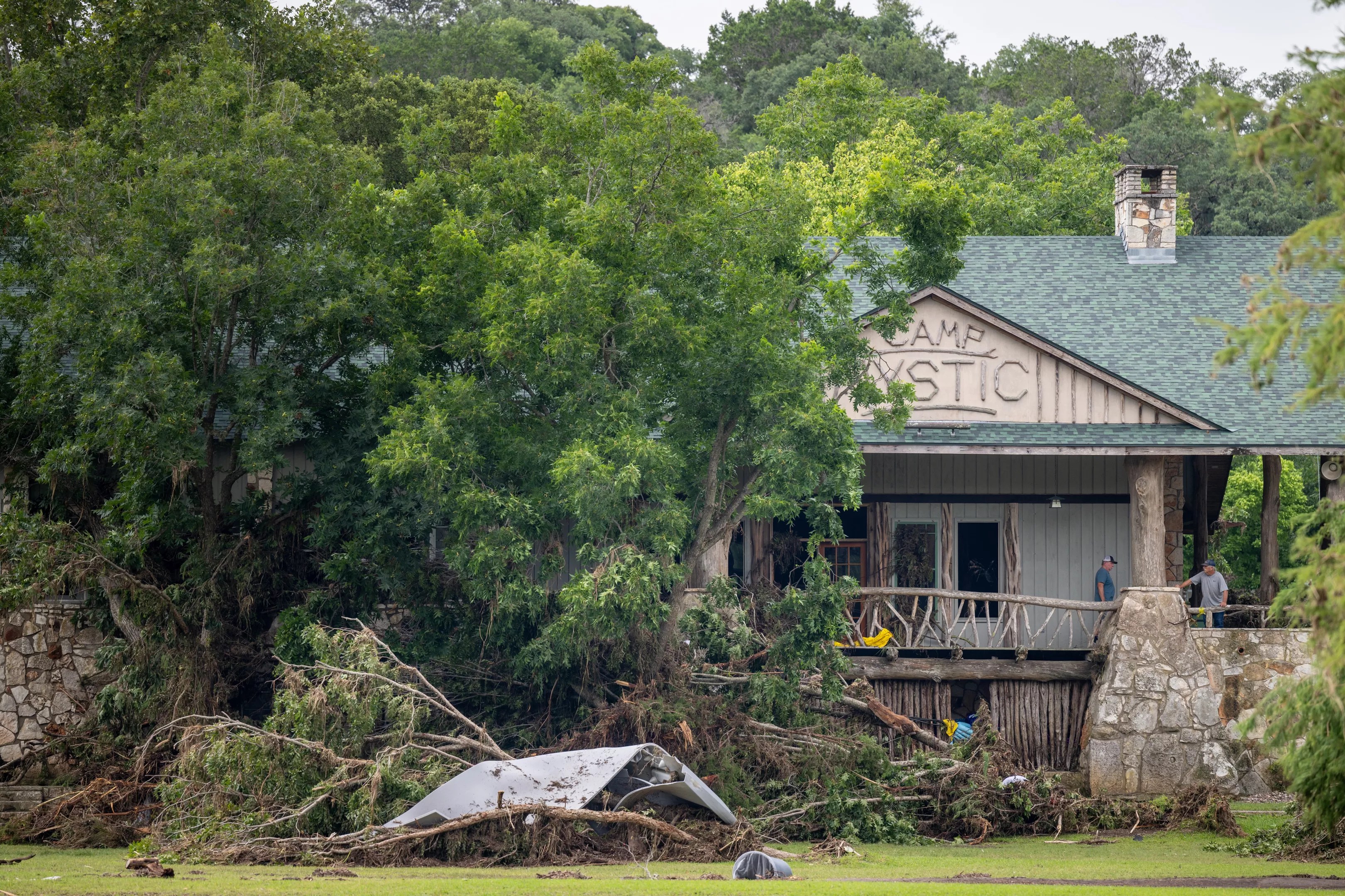
While officials urged state lawmakers to overhaul a number of flood and emergency-related protocols, much of the approved legislation focused on protections for summer camps.
Brandon Bell/Getty Images
The engineer declined the Observer’s request for comment, pointing us to the agency’s media office.
Program engineers do not regularly inspect “small and intermediate dams in the low hazard classification,” such as Rock Falls Lake, a TCEQ spokesperson said. The dam’s location in a high-risk flood zone does not factor into TCEQ’s assessment that the dam is low-hazard and should therefore be exempt from regular inspection. The spokesperson said that hazard classifications are reviewed “throughout the year” in response to citizen complaints, “using current aerial imagery, lidar elevation data, and TXDOT road classifications.” In some cases, dam safety officials may conduct field reviews.
Because the dam is ruled exempt, maintenance and upkeep are the responsibility of private owners. If the dam bursts, that’s on the private owners, too.
“In their mind, this is a 120-year-old dam that has never breached, so it’s low risk,” Kazansky said. “That’s like saying ‘I’ve lived 90 years so I’m never going to have a heart attack.'”
The letter added that the TCEQ does not regulate floodplains. It pointed Mayer to the Texas Water Development Board and his local floodplain administrator for help. In our reporting, both have been dead ends.
In 2021, the TCEQ published a report that announced the agency’s inability to keep up with needed dam inspections and maintenance across the state. To meet the needed level of annual dam inspections, the TCEQ’s dam safety program asked for additional staff positions to be created and for salary and benefits packages to be increased to attract better candidates for the job. The agency failed to complete all needed inspections in 2019 and 2020, a trend that “will continue to decrease each year.”
The report listed Texas’ growing population as a problem. As more people move to the state, more are living downstream of dams, heightening the associated hazard risks and creating the need for stricter regulations.
At the same time, flooding caused by heavy rain is more of a problem than ever, and in Texas, it’s expected to get worse over the next decade, NPR reports. Kazansky estimates that the Rock Falls Lake currently sits around 12 inches below the lip of the dam.
That’s about how much rain fell over Kerr County in the early morning hours of July 4.
“This has exposed a sad part of our state government,” Mayer said. “This isn’t a Mineola issue. This is an issue across Texas.”