
MarianVejcik via iStock

Audio By Carbonatix
Editor’s Note 2/17/2025, 10:24 a.m.: This article has been updated to include updated weather forecast information.
A polar vortex is upon us, according to WFAA weather guru Pete Delkus. Yes, another one.
“WARNING! WARNING! WARNING! The Polar Vortex looks like it’s going to unleash its fury on Texas!!,” Delkus wrote on X Friday morning. “Windchill’s below zero and a chance of a wintry mix!”
WARNING! WARNING! WARNING! The Polar Vortex looks like it’s going to unleash its fury on Texas!!
Windchill’s below zero and a chance of a wintry mix! 🥶— Pete Delkus (@wfaaweather) February 14, 2025
Delkus later added to X that things aren’t looking too vortex-ish on Friday at least, but we won’t have to wait long.
“Cloudy and chilly today with a few scattered showers tonight into Saturday morning (mainly east of DFW),” he wrote. “Morning clouds clear Saturday afternoon with highs in the 70s! A strong cold front brings a colder Sunday.”
It will get even more frigid on Tuesday and Wednesday when The Weather Channel predicts Tuesday’s low will hit 17 degrees. Wednesday will see a high of 30 degrees and a low of 13 degrees, while Thursday is set for a high of 35 degrees and a low of 23 degrees.
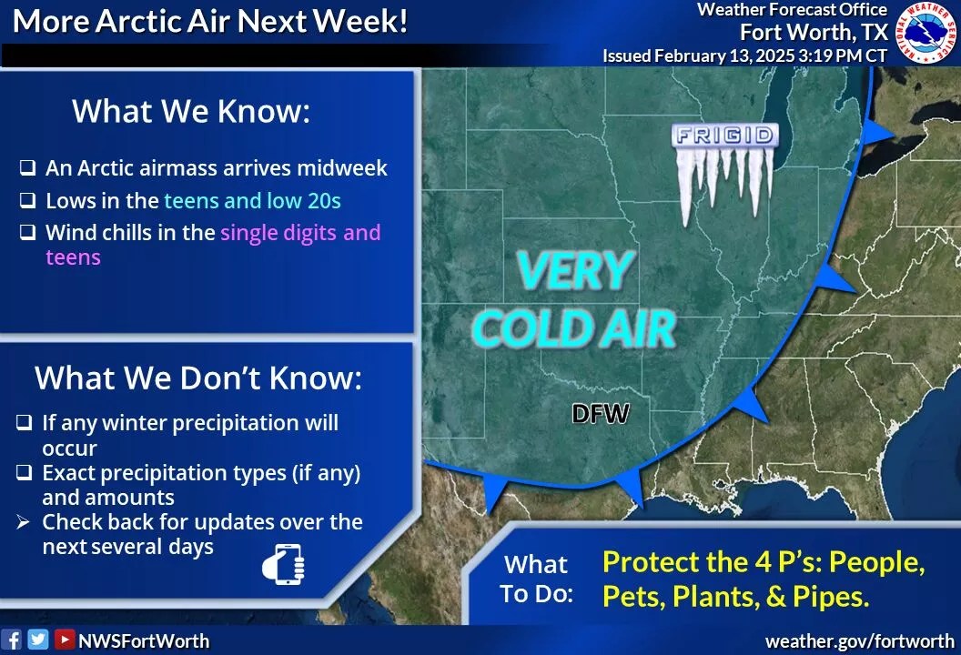
National Weather Service
The National Weather Service has also sounded the polar vortex alarm that seems to bring North Texans together much in the same way a historically horrible NBA trade does.
“Another strong arctic cold front will arrive around the middle of next week, dropping temperatures into the teens and lower 20s along with wind chills in the single digits to teens (Tuesday night and Wednesday night). It is uncertain at this time whether or not any winter precipitation will occur.”
On Monday morning, Delkus updated us with what to expect for this week. It’s not great.
“It was chilly this morning, but bitter cold is headed our way,” he wrote on X. “… Dangerously low temperatures and even lower wind chills are expected. We may see record-low temperatures on Thursday morning. Prep now!”