

Meredith Lawrence

Audio By Carbonatix
Keep Dallas Observer Free
We’re aiming to raise $10,000 by April 26. Your support ensures Dallas Observer can continue watching out for you and our community. No paywall. Always accessible. Daily online and weekly in print.
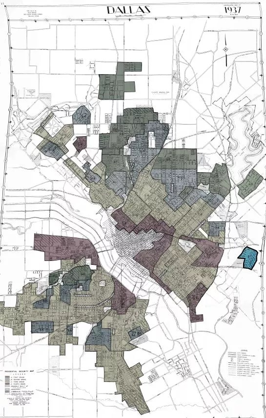
Racially based redlining practices divided Dallas and cities across the country for decades in ways that still affect neighborhoods today. An exhibit about the history of this practice and its effects, as well as what to do about it, will be on display in Dallas City Hall’s main lobby until Dec. 31.
“Red means a word I want you to keep in your mind: hazardous,” Victor Obaseki, Dallas’ equity officer, told a group of local advocates and city employees on a tour of the exhibit Wednesday afternoon.
The term “redlining” comes from a set of maps made by the Home Owner’s Loan Association in the 1930s. The maps were part of President Franklin Roosevelt’s New Deal plan to pull the country out of the Great Depression. On the surface, the maps offered banks a metric for protecting themselves from bad mortgages and loans, outlining economically disadvantaged neighborhoods across the country.
But the distinctions the maps made were overtly racist. The maps ranked each neighborhood on how many “foreign born” people lived there, their races and how many “Negro” inhabitants the areas had. In Dallas, and elsewhere, the maps divided the city into four categories: “best,” “still desirable,” “definitely declining” and “hazardous.”
“Look, there it is, a clear racial hierarchy written into the geography of every city in America.” — Victor Obaseki
Neighborhoods with black populations were categorically deemed “hazardous.” The maps steered banks away from lending in these neighborhoods. For years, the maps dictated where people could live, reinforcing segregation and suppressing economic investment and opportunity.
“Look, there it is, a clear racial hierarchy written into the geography of every city in America,” Obaseki said.
This structural racism seeped into the health and education systems, policing practices and economic setting in systemic disadvantages for people of color that persist in Dallas and across the country.
Included in the exhibit are a map of the Bronx in New York, to introduce redlining, and the redlined neighborhoods of Dallas. Each map is titled “Security Map.” In so naming the maps, the government cemented racial divisions and inequity into city plans and the social conciseness, Obaseki said.
“When you map this, you are mapping advantage and social disadvantage that builds … for generations,” he said.
New highways like Interstate 30 opened up pathways for wealthy white people to flee the cities for the suburbs and sliced through neighborhoods, further cutting them off from resources. As the money moved out of the city, resources for economically disadvantaged communities dwindled further.
Although they were outlawed by the 1968 Fair Housing Act, redlining maps continue to influence income, opportunity and economic well-being. Understanding that reality, as well as the history and factors behind it, are the first steps to undoing the decades of damage, Obaseki said.
“You’ve got to understand what’s happened,” he said.
The maps were recently digitized by researchers at the University of Richmond.
University of Richmond
Last year, the National Community Reinvestment Coalition released a report showing that neighborhoods singled out as hazardous by redlining are much more likely to struggle today than those that were not on the list.
Obaseki is Dallas’ first equity officer and in charge of the city’s new Office of Equity. One of his priorities in his first year in office was bringing this exhibit to City Hall and sharing it with city employees and agencies as well as Dallas residents and community organizations. He hopes it will help move Dallas toward more equitable policies and neighborhoods.
Undesign the Redline, as the exhibit is titled, is a series of five panels. It starts with two redlining maps and shows a detailed timeline of social and economic movements and factors tied to redlining and its impact, both nationally and in Dallas. The timeline is broken into two tracks: the high level, government and policy events, and the social movements that pushed back to change them. The final panel provides some beginning solutions for how to undo decades of damage.
“I’m excited. I think people have gotten a broader picture about Dallas and the ways it fits into the broader circumstances of equity,” Obaseki said.
Undesign the Redline will be available during City Hall business hours in the building’s lobby until Dec. 31.
Full digital and interactive versions of the maps available here.