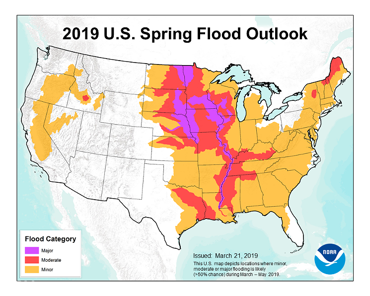
The forecast, which identifies areas in the Trinity River Basin as being at moderate flood risk, comes on the heels of catastrophic flooding in Nebraska and Iowa last week that killed four people.

The National Oceanic and Atmospheric Administration spring 2019 flood map
National Oceanic and Atmospheric Administration
“The extensive flooding we’ve seen in the past two weeks will continue through May and become more dire and may be exacerbated in the coming weeks as the water flows downstream,” Ed Clark, director of NOAA’s National Water Center, said Thursday. “This is shaping up to be a potentially unprecedented flood season, with more than 200 million people at risk for flooding in their communities.”
Conditions are primed across the country for an above-average risk of major flooding, Clark said, but the level of precipitation the U.S. sees this spring, in addition to the amount of snow that melts in the Upper Midwest as temperatures heat up, will go a long way to determining the strength of this spring's floods.
In Texas, increased spring precipitation and higher than normal soil moisture mean higher flood risks this spring along the Trinity, as well as the Neches and Sabine rivers in East Texas, NOAA's 2019 National Hydrologic Assessment says.
Moderate flooding, the kind that's expected in DFW, means that buildings and roads near the body of water that's flooding could themselves flood, potentially forcing evacuations, according to NOAA.
Texas can expect higher than average temperatures, as well as continued above-average precipitation this spring, NOAA's Jon Gottschalk said during a press conference Thursday. The persistent rain will continue to fight against the patches of drought that still exist in Texas, largely in the southern and central parts of the state.


